
What: Clairfield,Tennessee
Where: Hwy 90 Clairfield, TN
When: Settled 1825
Interesting Facts: Nestled along the scenic winding roads and rolling hills of the Appalachian Mountains, this historical mining town still holds a glimpse of the “coal camps” once documented by Caroline Kennedy while writing for the National Endowment for the Humanities. Known for its rich coal mining history, the rural community of Clairfield once had four mines and brought in the most revenue to the county due to the coal severance tax. Located outside Cumberland Gap, this unique section of Claiborne County is a “must drive” route which ends a few miles south of the historic Speedwell Academy.
What: Speedwell Academy
Where: 220 Academy Rd. Speedwell, TN
When: Constructed in 1827
Interesting Facts: The Academy building site was donated by George Shutter and consisted of 114 acres. Mr. Shutter, a German immigrant who migrated to Powell Valley about 1800, lived in Pennsylvania. Mr. Shutter had no children but believed very strongly in education. He supplied the slave labor and money for the building of the Academy which would become the Powell Valley Academy for Males. The building was listed on the National Register of Historic Places in 1995 for its contribution to the social and educational history of Claiborne County.
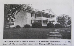
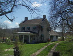
What: McClain-Ellison House
Where: West of Speedwell on Route 2 off State Route 63
When: 1793-1800
Interesting Facts: This house is significant because it is one of the oldest surviving structures in Tennessee. It is on the Historic Registry and it is the oldest home nominated to the Register from Claiborne County. It is made of hand cut lime stone, said to have been quarried on a nearby site by a single slave. The walls vary in size from 8 feet thick to 2 feet thick. Because the house is backed into a hill, the backside of the house is three stories high with the front being two stories high. The builder, Thomas Ellison, was one of the first white men to settle in Powell Valley. Before the house was built, he and his wife stayed in a cave. Indians, especially the Cherokee were the predominant inhabitants of the area at that time. A belfry was placed on the house and it was used to warn settlers if the Indians were coming. Today this house is a private residence and sits on a secluded dirt road in Powell Valley. The house faces directly south away from Powell Mountain and looks towards the valley's rolling hills.
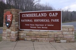
What: Cumberland Gap National Historical Park
Where: Park entrances at Middlesboro, KY and Cumberland Gap, TN
When: Established on June 11, 1940
Interesting Fact: The Park was established to celebrate the Cumberland Gap’s role in the westward expansion of the United States.
Where: Park entrances at Middlesboro, KY and Cumberland Gap, TN
When: Established on June 11, 1940
Interesting Fact: The Park was established to celebrate the Cumberland Gap’s role in the westward expansion of the United States.
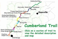
What: The Cumberland Trail
Where: The trail begins at Cumberland Gap National Historical Park and ends at Chickamauga and Chattanooga National Military Park and Prentice Cooper Wildlife Management Area just outside Chattanooga.
When: in progress
Interesting Fact: The Cumberland Trail is a hiking trail following a line of ridges and gorges along the eastern ridge of the Cumberland Plateau in Tennessee. A work-in-progress, the Cumberland Trail is a remote footpath that will pass north to south through 11 Tennessee counties on the eastern ridge of the Cumberland Plateau. Presently, 176 miles are maintained and open for hiking and other outdoor activities.
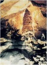
What: Gap Cave
Where: Cumberland Gap National Historical Park Daniel Boone Parking Center
When: 1750
Interesting Fact: Throughout the years Gap Cave has had many names. It was named first by Dr. Thomas Walker in 1750, who named it Gap Cave. In the 1890s commercial tours of the cave began. In 1864 J. T. Trowbridge published a novel Cudjo’s Cave, about a slave that had escaped and was hiding out in a cave in the Cumberland Gap. This book was quite famous at the time and the setting for Cudjo’s is approximately the same as Gap Cave. The cave owners changed the cave's name to Cudjo’s Cave to attract tourists. Tours of the cave may be booked by reservation only.
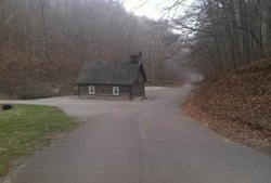
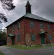
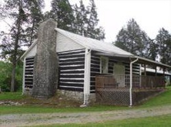
What: Leatherwood Baptist Church
When: Founded 1890
Where: 1322 Leatherwood Hollow Road New Tazewell, TN
Interesting Facts: Leatherwood Church received its name from a tree that was tough as leather. This log cabin church still has regular services.
When: Founded 1890
Where: 1322 Leatherwood Hollow Road New Tazewell, TN
Interesting Facts: Leatherwood Church received its name from a tree that was tough as leather. This log cabin church still has regular services.
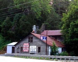
What: Johnson’s Mill
Where: 4105 Hwy. 33 New Tazewell, TN
When: Founded late 1880’S
Interesting Facts: Johnson’s Mill has been a family owned business for four generations. The water wheel is still operational but it is now run by a diesel powered mill to grind corn and oats to make feed. Also of interest, this waypoint along the Appalachian Quilt Trail is part of Claiborne County, Tennessee within the East TN region. The historic Johnson Mill proudly displays the Tennessee Red Tulip.
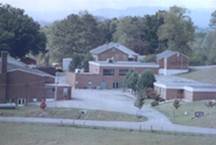
What: Forge Ridge School
Where: 160 Hill Rd Harrogate, TN
When: 1928
Interesting Facts: The four-room brick that was to be the beginning of Forge Ridge School was built in 1928. A.H. Hill donated the land, and some citizens and community members contributed both labor and money. The stone building that is on campus was built in 1940-1941. There was once an old forge for an iron works, located on Indian Creek a few hundred yards down the creek from the school by the bridge on Hwy 63 East. This ironworks forge was originally owned by Robert Crockett and his brother Andrew Crockett. When Forge Ridge School was in the process of being named, William I. Bolton, the Principal of Greers Chapel School, suggested naming the school and community Forge Ridge, because of the proximity of the Forge at the base of the ridge. It is the longest continuously operating school in Claiborne County still housed in original buildings.
What: Big Spring Primitive Baptist Church
Where: 152 Lone Mountain Rd., Tazewell
When: The church was built circa 1795 or 1796, and was known at first as Big Spring Meetinghouse.
Interesting Fact: A Baptist church was organized at the site in 1800. During the Civil War, it served as a hospital for both Confederate and Union Army troops. It is one of the oldest church buildings in Tennessee that is still in active use as a church. It was added to the National Register of Historic Places in 1975. The Tennessee State Library and Archives holds a copy of the records of Big Spring Primitive Baptist Church for the years 1800 through 1948
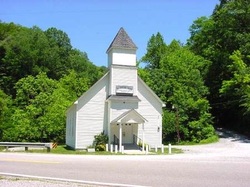
What: Big Spring Union Baptist Church
Where: 7460 Hopewell Rd., Harrogate, TN
When: Organized 1856
Interesting Fact: Named for the fresh water springs located nearby where passersby still stop and get a refreshing drink. Also of interest is the bloody shootout which reportedly took place outside the church near the spring during a service in 1901. According to several newspapers of the time, it was a feud between two families and four people were killed.
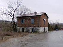
What: The Old Jail
Where: Hwy 25E Tazewell, TN
When: Erected in 1819 and in use until 1932.
Interesting Fact: The Claiborne County Historical and Genealogical Society holds the deed to the historical Old Jail located in Tazewell on what was once a back street of the town of Tazewell but now is main State Highway 33E. It was constructed of logs with an outside wall of stone. The second story is brick.
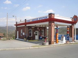
What: Rose Gulf Service Station
Where: Old 25E Tazewell,TN
When: Built in 1930 as a Gulf Service Station
Interesting Fact: It was built by Gulf Oil distributor Carson Rose and operated as a service station through 1956 by several different people. It was a residence from 1956-1988. In 2001 the town of Tazewell purchased the property and in 2001 restored it back to its authentic condition, representing a Gulf "filling station" from days long past. It has been turned in to a museum and held its grand opening May 9, 2002.
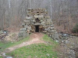
What: Iron Furnace
Where: Cumberland Gap National Historic Park
When: 1819
Interesting Fact: Although all that remains is the lower portion of the original 1819 30-foot-high blast furnace, it is actually a very small part of what was originally an entire complex known as the Newlee Iron Furnace. The furnace was in operation from about 1820 until 1880 (except for the Civil War years). It was here that limestone and iron ore were heated by coal and converted to "pig iron," which was then shipped to factories. This particular iron furnace employed up to 300 men and made supplies such as: rifles, broad axe, and cooking utensils for life on the frontier.
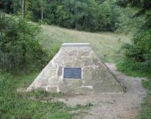
What: Tri-State Peak and Marker
Where: Cumberland Gap National Historical Park
Interesting Facts: You can stand in three states at once. Walking through the park, you come to this structure, built at the exact spot where Tennessee, Kentucky and Virginia converge (Lines are drawn that show you the exact state lines). A few feet away you'll see a sign that indicates that this was the "Royal Colonial Boundary" of 1665. In other words, in 1665 surveyors established this spot to be the far edge of their American colony. Colonists weren't supposed to go any further into America than this spot.

What: Cumberland Gap Tunnel
Where: TN / KY State Line – US 25E
When: Construction began 6/21/1991 – Opened 10/18/1996
Interesting Facts: The Cumberland Gap Tunnel is a tunnel that carries US Route 25E under Cumberland Gap National Historical Park near the intersection of Kentucky, Tennessee, and Virginia. The east portal of the tunnel is in Tennessee and the west portal is in Kentucky. It is one of only two mountain vehicular tunnels in the United States that cross a state line.
What: Graham-Kivett House
Where: Jct. of Main St. and Old Knoxville Rd., Tazewell
When: built circa 1810
Interesting Facts: The Graham-Kivett House is the oldest home in Tazewell and one of only a few buildings that survived a disastrous fire in 1862. It was built by William Graham, a merchant and one of the founders of Tazewell. James Kivett acquired the home at the turn of the 20th century from William Yoakam, its then current owner. Kivett was a lawyer and coal mine operator. His daughter, Louise Kivett Redman, was a novelist and had several books published.
What: The Nelson Stone-Buis House
Where: Eppes St. Tazewell, TN
When: The house was built by Dr. Nelson Stone (1866-1933), a Claiborne County dentist.
Interesting Facts: The Nelson Stone House was erected during the early 1900’s; however, there was an historical event which took place several years earlier on the building site. In 1862, during the Civil War, the courthouse records were piled on this vacant lot to prevent them from being destroyed. Benjamin Cloud discovered the courthouse was on fire, and with the help of his son H.M. Cloud, they carried the legal documents from the courthouse to this lot. Some years later, Dr. Nelson Stone, a Tazewell dentist, erected a large stone residence here. The architecture of this spacious home is quite unique, and there is an unusual attached silo-type column behind the residence for storing coal for heating the house. It was used as the “Reese Hotel” from the 1930’s to the early 1950s, and was purchased for a residence by Joe Buis in 1956. The property remains privately owned today.

What: Helm’s Ferry
Where: 1150 Straight Branch Rd., Speedwell, TN
Interesting Facts: It is one of the last operating ferries in East Tennessee. It connects portions of Union County that are separated by the Powell River. One can cross from Union County into the Speedwell area of Claiborne County by the ferry. Prior to the building of Norris Dam in 1933-1936, many small communities along the Clinch and Powell rivers were dependent on ferries to transport individuals across the rivers.
Download a Copy of the Map
| claiborne_county_historical_interest_map_2014.pdf |
